
Truro Flood Risk Study
CBCL Limited
» Scope of Project
The Town of Truro, Nova Scotia, is notorious for being subject to flooding more often than any developed area in Atlantic Canada due to the complex interaction between the highest tides in the world, very large runoff flows, river sedimentation and recurring ice jams. The Truro Flood Risk Study was commissioned by the Joint Flood Advisory Committee, or JFAC (County of Colchester, town of Truro, and Millbrook First Nations). As the most comprehensive flood study ever undertaken in Atlantic Canada, the Committee and CBCL Limited’s water resources group had very ambitious goals: to find flood protection solutions where decades - perhaps centuries - of studies had not been able to resolve the complex mechanisms underlying flooding risks in Truro.
» Execution
A fundamental principle of the Study was to include the full range of stakeholders throughout the project. The project team asked stakeholders to identify infrastructure and services that are most valuable to them and rank them by priority. This prioritized list of vital infrastructure then formed the basis for evaluating the efficiency of various flood mitigation options, ensuring that the preferred options protected the most important and most vulnerable infrastructure, services and land for each stakeholder.
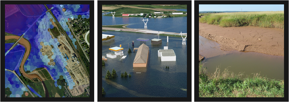
The Study incorporated the latest computer modelling techniques built upon Lidar mapping for the entire watershed, high resolution aerial photography, bathymetric surveys and near infrared satellite imagery. No previous study had been able to characterize the full range of risks, let alone find solutions to protect the residents of Truro. With this Study, CBCL Limited water resources engineers and technicians gathered the most current, detailed and accurate data, processed it with the most advanced models available and produced a uniquely representative understanding of the estuary in order to test a wide range of potential options for flood mitigation. Four computer models were assembled in order to study the relative influences of extreme rainfall, tides, estuary sedimentation and ice jams. With each of these models more than 40 flood mitigation options were evaluated and, based on the extensive stakeholder consultations held at the beginning of the project, each option was ranked by its ability to cost-effectively protect the vulnerable areas vital to each stakeholder. This project focused so much on improving the analysis through increased detail and modelling depth that a significant amount of information needed to be collected, stored and managed. Current computing technology was pushed to its limits to achieve the highest level of detail and depth of analysis that the available time and budget would allow.
» Project Highlights
Though few ice jam models exist, CBCL Limited’s water resources group took up the challenge in order to study the risks of formation of ice jams at various locations and various flow and winter conditions.
Quantifying rainfall changes across the watersheds is one of the largest sources of uncertainty in hydrologic modelling - to overcome this, the innovative idea of using rainfall radar data was identified.
Creativity became a constant characteristic of the project as a necessary means to problem-solving.
The Truro Flood Risk Study acts as a benchmark for infrastructure design within the floodplain as well as a base for predicting how future weather events will affect the community.
The Study aims ultimately to reduce the costs of flood protection, protect infrastructure and keep Truro residents safe from harm caused by flooding. Short term and long term measures include changes to planning and policy regulations and emergency management operations, going from low profile lot scale measures to large scale heavy infrastructure projects. Some proposed measures include creating permeable pavement and rain gardens, widening and raising the dyke system to restore the natural floodplain and salt marsh, and implementing a flood forecasting and warning system to allow residents to better prepare for flooding. Ultimately, a safer environment will promote a healthier economic environment where stakeholders will be more confident investing in the future

